Katahdin Woods and Waters National Monument Huts
Stacyville, Maine · National Park Service
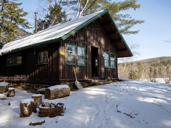
Photo: Recreation.gov
About
Katahdin Woods and Waters National Monument is located in Maine’s north woods. Katahdin Woods and Waters protects part of an extraordinary natural and cultural landscape: the mountains, woods, and waters where the East Branch of the Penobscot River and its tributaries, including the Wassataquoik Stream and the Seboeis River, run freely. Huts located in the north end of the monument provide opportunities to stay overnight while cross-country skiing, snowshoeing and enjoying other recreational activities. The East Branch of the Penobscot River flows all the way through the monument, about 25 miles from north to south. The first 10 miles drops over 200ft, creating a series of waterfalls and rapids (Stair Falls, Haskell Rock Pitch, Pond Pitch, Grand Pitch, the Hulling Machine, and Bowlin Falls). The Seboeis River and Wassataquoik Stream also create scenic viewpoints in the monument, such as Orin Falls. Katahdin Woods and Waters is known for its dark skies. In 2020 it was certified as an International Dark Sky Sanctuary. Forest, waterways, and wetlands provide critical habitat and corridors for plants and wildlife, including threatened species such as Atlantic salmon, Canada lynx, and rare mussels and butterflies. Geological formations are throughout the monument. Haskell Rock is a 20-foot tall conglomerate bedrock pillar in the East Branch. Popular hikes include trails on Barnard, Deasey, and Lunksoos Mountains.Baxter State Park (where Katahdin and the A.T. are located) is adjacent to the western boundary of Katahdin Woods and Waters National Monument. There are many ways visitors can experience Katahdin Woods and Waters National Monument. Below are a few recommended activities: Cross-country skiing and snowshoeing in the winter: The monument provides a limited area of groomed cross-country trails at the North Gate for visitors to use. Hiking: Choose a hike that meets your abilities to observe the biodiversity of the monument. Biking: Bike on historic logging roads (current and former) within the monument that display signs of logging activity that dates back as early as the 1800s. Camping: Sleep under the stars. Katahdin Woods and Waters is an International Dark Sky Sanctuary, the first to be certified in the state of Maine and in New England. Paddling: Paddlers can experience the scenic hydraulic features that are ecologically and culturally significant within the monument. The streams and rivers within the monument provide important habitat for spawning and
Directions
Katahdin Woods and Waters National Monument is located in north central Maine, approximately a 2-hour drive northwest of Acadia National Park in Bar Harbor and 1.5-hour drive north of Bangor, Maine. Both areas are served by regional airports. You can access all parts of the monument from I-95. Take exit 244 (Medway) or exit 264 (Sherman) to access Maine Route 11. Once you exit I-95, you will travel on Maine Route 11 to access the monument. If you are southbound on I-95, you can also access the monument from exit 276 (Island Falls). Maine Route 11 is the main access route to the monument. It is also known as the Katahdin Woods and Waters National Scenic Byway. North Entrance From Exit 244 (Medway), head west for approximately 0.8 miles towards Medway and turn right onto Route 11 (also called Grindstone Road). If you cross the East Branch of the Penobscot River, you have missed the turn for Route 11 north. Continue north on Maine Route 11 to Patten. Turn left onto Maine Route 159 (also called Shin Pond Road). Maine Route 159 continues for approximately 11.6 miles and then becomes Grand Lake Road. Continue on Grand Lake Road for another approximately 12.7 miles, then turn left onto New River Road (also known as Messer Pond Road) to access the North Entrance. From Exit 264 (Sherman), follow signs for Maine Route 11 north towards Patten. In approximately 10 miles, turn left onto Maine Route 159 (also called Shin Pond Road). Maine Route 159 continues for approximately 11.6 miles an
Location
Map tiles © OpenStreetMap.
Details
- State
- Maine
- City / area
- Stacyville
- Agency
- National Park Service
- Parent area
- Katahdin Woods and Waters National Monument
- Campsites
- 2
- Reservable
- Yes
- Typical price
- See Recreation.gov
- Rating
- 5.00 / 5 (4 reviews on Recreation.gov)
- Equipment
- See Recreation.gov